 Turns out we weren’t the only ones running late.
From Seatoller to the top of Honister, where a slate mine stands sentry at the dramatic gateway between Borrowdale and Buttermere, is a mile and a half of uphill walking.
As we eased our way uphill, happy now to stop every hundred metres in order to turn a full 360 degrees for the view, we saw only cars. No people.
It was a different story when we reached the mine, where anxious stewards in fluorescent vests scanned the fells to the east, muttering to each other about there not being enough time. Close by a trestle table held a few mean plastic beakers of very weak orange squash.
We were ready for refreshment and parked our rucksacks and sticks close enough to be able to follow the unfolding drama. This was a 10 in 10 event for an MS charity: ten miles in ten hours, which would be generous on flat ground, but appeared to involve something like ten serious peaks as well.
(For the record Shushie and I reckon on averaging two miles an hour for the Coast to Coast, the frequent uphills and our commitment to regular stopping to simply sit and look, compensating for those times on the flat when our feet are flying – er hum – at least for the first few hours of the day.)
The stragglers huffing and puffing into sight were, it emerged, almost six hours into their allotted ten, and had so far clocked up just four miles. Someone at head office had clearly never been walking in the Lakeland fells.
Clueless
To add to our rather ungenerous sense of superiority, as Shushie took photos, a lycra-ed cyclist heaved up to me from the steep climb we’d just done.
“Is that an OS map?” his bike rammed into my leg but then there was so much sweat on his face I imagine he couldn’t see what he was doing.
“Can you show me where we are on it?”
I did of course, all the while thinking ‘bloody hell, this is Honister Pass, one of the most famous intersections in the Lakes, and we are sitting outside Honister slate mine, which is on not only on every map but has a dirty great sign on it. How is it you would ride a mile and a half uphill in scorching sunshine without knowing where you are going?’
One thing we were to learn that day was that come the summer, come the crowd who don’t know a compass from a cucumber sandwich. And on any other day but one such as this, with perfect conditions, panoramic views as far as the Irish Sea, and plenty of people with maps to ask, would be a huge liability to themselves.
You will be aware, of course, from previous posts in this blog, that the only reason Shushie and I recognised this phenomenon was because we had been there and been equally clueless on our first Coast to Coast crossing. We were not so superior now that we didn’t feel a little anxious for all those coming in the opposite direction from Ennerdale clutching nothing more than a roughly photocopied sketch of their route, and no idea that the Lakeland fells would be so, well, high!
On top of the world
 Talking of which, there was no let-up in the gradient after our coffee stop.
Leaving behind the school groups and coaches at Honister Slate Mine the route joins a disused – vertical – tramline, introduced to save quarry workers from the dangerous job of bringing Honister’s prized green slate down from the fells on hurdles, which they walked in front of as human brakes on the weight.
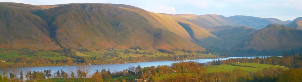
But each upward step on slippery shale was, we knew, bringing us closer to one of Lakeland’s stop-in-your-tracks-and-know-there-is-a-heaven views: out towards Buttermere and its neighbour Crummock Water, nestling in the lee of Haystacks, beneath High Crag and High Stile, overlooked by Fleetwith Pike.
There was nothing to do when we reached the top but stop. And sit. And wonder at it all.
To commit it to memory, to bring us back aloft on all the future days when our boots were mired in mud, or grey skies threatened to overwhelm us.
Everything was in such sharp relief: every shadow cast by fluffy clouds on the soft velvet of the slopes; the dancing light and shade of the lakes below; grey rock jagging out from the summits like the teeth of a predator; narrow stone paths picking a way across the fells; in the distance, all this wildness flattening to yellow fields and beyond the suggestion of pale sea; in front of us, across the plunging valley towards Hay Stacks, the merest glimpse of mountain lake – Innonimate Tarn where Wainwright, our guide, chose to have his ashes scattered.
Of all the fells and dales he walked, this place, this view, was where he felt he would find the most peace through eternity.
And on this day, drinking it all in as thirstily as if our veins had become dessicated during the long, long months before, we could not argue.

Stumbling and signs
For a mile or so, the Coast to Coast route stays on top of the world, following the colourfully named Moses’ Trod – an old cairned road, along which the slate was transported to Wasdale and the west coast. But Moses was more interested in another kind of hard stuff. According to folklore he made his living from distilling and selling moonshine amongst the felltop crags.Perhaps Moses’ Stumbled might have been a more accurate name for this lovely path.
Eventually it was time to leave our mountaintop via the steep descent of Loft Beck, a kind of chimney stack plunging down into the valley of Ennerdale, between rocks and gulleys so you are forced to twist your body and legs every few steps to accommodate a new angle in the gradient.
Here it was that Shushie and I encountered the same groups of walkers we’d seen leaving Ennerdale Bridge that morning, only now they no longer looked fresh in their new boots and shiny walking gear, but bothered and tentative. Where were they? Were they on the right route, they asked us? Was there far to go? And, lower down, were they even capable of such a relentlessly demanding climb aloft?
cruelty to trees

Company in the forest
Even at the bottom of Loft Beck we were still less than halfway through the day’s allotted 14 miles. For the Ennerdale Valley is only partly silver lake. Coming from the east there are some four miles of forest to march through before the shining waters of this remote silent lake are glimpsed.
It didn’t matter: we were loving every minute of the day, our bodies were working well despite their recent lack of use, the sun was still shining, and we now we’d crossed over with the west to easters we had the whole lovely valley entirely to ourselves.
We sped past Black Sail Hut – claimed as the most remote youth hostel in England – our eyes constantly turning back to the great tombstones of Great Gable and then of Pillar, solid grey walls of rock rising from the valley floor to intersect with the giants that can be found in the neighbouring Wasdale valley.
Into the forest proper, which had once seemed to us as it seemed to Wainwright: a mutation.
You can hear his gruff Yorkshire voice in what he writes: “Where there are now plantations of conifers there used to be fellsides open to the sky, singing birds and grazing sheep. It was Herdwick country…Those of us old enough to remember the valley as it was are saddened by the transformation. Lovers of trees paradoxically will not like the hundreds of thousands that make up Ennerdale Forest: deformed, crowded in a battery, denied light and air and natural growth. Trees ought to be objects of admiration, not pity. Trees have life, but thank goodness they have no feelings else here would be cruelty on a mammoth scale.”
Since his time, and ours too, the landscape has been altered in both negative and positive ways: a disease has killed off the larch trees, their loss opening up the canopy, while the Forestry Commission, no doubt stung by the way followers of Wainwright’s route have amplified his criticisms, has begun a programme of planting native species.
As we walked we could clearly see into the forest – it was no longer an inpenetrable olive wall – while on both sides of the path banks of wildflowers thrived. Apart from our boots, perfectly in time, the loudest sound was the buzz of bees gorging on the nectar of purple wild orchids, pink campion and daisies, while the occasional fat dragonfly dined on the midge clouds which accompanied us.
Robin Hood’s again
 We talked too.
Deliberately. Conscious of the approaching end of this Coast to Coast crossing.
Recalling highlights and lowlights. Musing together on lessons learned. But I shall save that for another post, since this is already as long as Ennerdale itself.
We reached the lake finally, following the narrow shore path which teeters over tree roots as complex as tangled wool, spreading over and around the rocky path in search of something to fasten onto.
And as we picked our way among the rocks and routes, the scent in the air was of the sea, though that still lay some miles ahead. Perhaps it was no more than our imaginations but with white horses racing across the lakes’ surface, the rich tang of weed, it was a taster of what was to come the next day.
 We continued to allow ourselves to stop, despite the deepening day, stripping of boots and socks to cool our feet in the lake. And to look back towards the head of the valley where clouds were now mustering, darkening the fellsides and, by contrast, intensifying the golden late afternoon sun shining our way home, turning the lake into liquid light.
We were leaving the fierce felltops behind, but only with our bodies. Our spirits remained aloft, drunk as that man Moses on all the beauty we had seen that day; all the awe we had felt, all the peace we had found.
Ennerdale had one final challenge for us: Robin Hood’s Chair, a strange rock promontory jutting out into the lake, where the path effectively disappears and the only way past is by scrambling over its top, with extreme care. Our guide books were silent on the subject of why this obstacle, so remote from Sherwood Forest, is named for the outlaw, but as they point out, it’s a neat connection between the almost start and end of the Coast to Coast walk.
Actually, there was another challenge for two walkers who, after all that road walking through the forest, fully understood the meaning of the expression ‘footsore’: another mile and a half on tarmac to bring us into Ennerdale Bridge, the village.
We have noted often how much longer than a mile is the final mile of any day’s walking. This one went on for ever and the only thing that helped us continue to put one tired boot in front of the other was the thought of sharing a celebratory cider once we reached the village.
We’d arranged to call Barry for a lift back to the car in Cockermouth and he was as good as his word, standing by to get our call and saying it would take him 20 minutes to reach us. The perfect amount of time to buy a cold, cold cider and sit with it outside The Shepherd’s Arms in the sunshine, looking out towards the fells that had been with us all day, with full hearts and utter satisfaction.
